Teren’s Spring 2023 Appalachian LiDAR collection is just around the corner. Whether you’re working on a new project or evaluating the environment surrounding your assets, now is the best time to capture data while leaves are still off and before trees begin to bud. With Teren’s powerful processing platform, our content region clients will have high-fidelity data in their hands before summer break.
If you’re new to the program or considering joining Teren’s Spring collection, here’s a few FAQ’s that we thought would be helpful.
What’s New in 2023?
Over the winter, Teren worked closely with our aerial acquisition partners to select the best-of-the-best for our clients. With new requirements in place, we can deliver higher quality data faster than anyone, and provide redundancy on collection to ensure schedules stay intact.
Isn’t Teren an aerial acquisition company?
No. Teren is a data and analytics platform provider. We partner with aerial acquisition firms to alleviate the burden of coordinating flight schedules and ground controls from our clients. At Teren, we focus on integrating, processing and analyzing remotely-sensed data to deliver actionable insights that allow clients to build and operate more resilient infrastructure.
What is a “Content Region”?
Teren is amassing a content library of remotely-sensed 3D (spatial) data across the United States. In our content regions, the data is updated on regular intervals specific to the regional weather, temperament and earth movement to monitor changes over time – providing a unique 4D (temporal) view. The content regions in Appalachia and OK/AR feed analytics that identify risk, inform mitigation, and strengthen resilience.
Who can access the content region?
Teren’s content regions are available to anyone who needs high-fidelity, temporally-relevant data.
- Civil engineering firms leverage Teren’s content region to understand hydrology flow paths for stormwater planning and use contours to evaluate cut/fill needs
- Renewable developers use terrain analytics to best understand slope and grading as well as vegetation information to estimate clearing costs and shading
- Asset owners gain insights into the external force threats that could impact their infrastructure to take proactive mitigation measures and fortify their assets
From new projects to operational assets, Teren’s content region provides spatially accurate and temporally relevant data.
How is it different from 3DEP?
While 3DEP is a good source for high-level planning, it can often be up to a year old. Teren provides high-fidelity data on regular intervals to capture changes to terrain, hydrology and encroachments over time. Teren can deliver much more time-relevant data than 3DEP to help you understand what’s happening in near real-time.
Why Work with Teren?
Teren is the only solution that can provide end-to-end remotely-sensed data, analytics and intelligence at the pace of business. Our innovative approach solves today’s challenge of working with remotely-sensed data by applying the processing speed and automation of the future.
How fast is Teren?
We’re the fastest LiDAR data processing solution available. We think about our collection and delivery as 1:1. For every one day of collection, we need one day of processing. No one else can promise that.
What is Teren’s accuracy?
Resolution: 40cm GSD
LiDAR Pulse Density: 20 PPM
Vertical Accuracy: +/- 14cm
Horizontal Accuracy: +/- 40cm
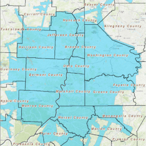
Where, exactly, is Teren’s Appalachian Coverage?
Teren collects 12,000 square miles in Appalachia (current footprint is below). However, we’re steadily growing in Oklahoma, Arkansas, Colorado and California as well. If you’re in or near the Appalachia coverage, there’s still time to get in on our Spring collection. Contact us today.
How can Teren help you?
We'd love to hear from you.
- Ready to dive deeper? -
Knowledge Hub
White Papers
Webinars