The future of geospatial data is boundless, with an ever-increasing number of companies and industries finding ways to harness its power.
Yet despite geospatial data being more common in decision making across industries, we at Teren still observe large gaps in understanding the different types of data, their different use cases, and different considerations in selecting and applying the right type of spatial data fit for the purpose of a particular project.
This series is a step in laying out the basics of geospatial data without having to go back to school. Let the geospatial data bootcamp begin!
What is Geospatial Data?
Geospatial data refers to information that is associated with a specific location on the Earth. You can break the word down into ‘spatial data’ – data that takes up space – and ‘geo’ – referenced to the Earth.
Geospatial data (sometimes just referenced as ‘spatial data’) is used to map and analyze various features and phenomena in the world, providing insights into patterns, relationships, and trends across different spatial environments.
Types of Geospatial Data:
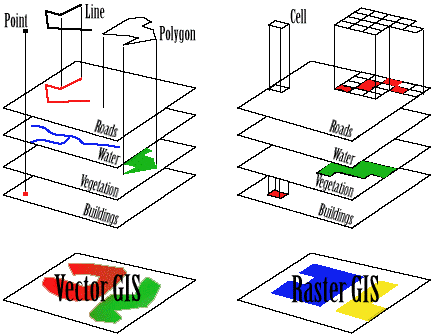
- Vector Data:
Vector data represents real-world features using “geometry” datasets of points, lines, and polygons. Points can denote specific locations like cities or GPS coordinates, lines can represent roads or rivers, and polygons can outline areas like lakes, parks, or political boundaries. These geometric representations can change with different scales, and can have rules in the dataset like “the road crosses the river at the bridge.” These rules are called topology in vector datasets. - Raster Data:
Raster data consists of a continuous grid of pixels, each with an associated value representing information like elevation, temperature, or land cover. Satellite images, weather radar maps, and even photos taken with your smartphone/digital camera are common examples of raster data.
Sources of Geospatial Data:
Imagery:
Imagery refers to photographs or images captured from digital sensor platforms. These images can be taken in various spectral bands, including visible light, infrared, and multispectral. Imagery provides a detailed visual representation of the Earth’s surface, allowing for the identification of features such as vegetation, water bodies, urban areas, and land use patterns. High-resolution imagery is essential for mapping, monitoring changes over time, and supporting decision-making in fields like agriculture, forestry, urban planning, and environmental conservation.
LiDAR (Light Detection and Ranging):
Aerial collections also can conduct LiDAR data. LiDAR uses laser light to measure distances to the Earth’s surface. An aerial platform, such as a drone or airplane, emits rapid laser pulses toward the ground. These pulses reflect back to the sensor, and the time taken for the light to return is measured to determine the distance between the sensor and target objects. By integrating this data with high-fidelity (accurate/precise) GPS, LiDAR provides precise 3D models.
SAR (Synthetic Aperture Radar):
SAR is a form of radar used to create detailed images of the Earth’s surface. Unlike traditional optical imagery, SAR can penetrate through clouds and is capable of collecting data day or night, making it highly reliable in all weather conditions. An aerial or satellite platform emits radar waves toward the ground, and the reflected signals are captured to generate images. SAR data is valuable for applications like surface deformation monitoring, flood mapping, land cover classification, and agricultural assessment. Its ability to detect changes in surface characteristics over time makes it an essential tool for monitoring natural and human-induced changes on the Earth’s surface.
Platforms for Collecting Geospatial Data:
Terrestrial (Ground) Platforms
- Surveying and Mapping:
Surveying and mapping are considered the traditional methods that provide highly accurate land records and topographical data. These methods are now most often used to validate and calibrate remote sensing data.
Remote Sensing Platforms:
Many sources of geospatial data come from remote sensing, also known as “Earth Observation” or EO for short. Remote sensing means to gather information about the Earth without direct contact of a sensor or sample. It mostly involves the use of satellite or airborne sensors to collect data on various environmental and man-made features.
- Helicopter, Drone & Aerial:
Aerial collection, or data captured using various platforms such as drones, helicopters, and airplanes, can provide highly detailed views anywhere from under a single square kilometer up to hundreds of square kilometers, making them ideal for precise mapping, and at local to regional scale studies. - Satellite:
Satellite provides comprehensive coverage of the Earth’s surface, useful for mapping terrain, monitoring environmental changes, and urban planning. Satellites capture images of the entire planet, allowing for consistent and regular monitoring of large and remote areas. They use a technique called InSAR (Interferometric Synthetic Aperture Radar) to do this, which can monitor ground movement down to the centimeter! Satellites are also great platforms for hyperspectral and multispectral imaging, or images in multiple spectral bands (e.g., visible, infrared), enabling detailed analysis of different land and water features. These satellites can be in geostationary orbits and fixed to a specific view of Earth, or can be in low earth orbits, meaning they are closer to the planet and orbit dozens of times a day.

Applications of Geospatial Data:
This list is growing every day, but some of the main applications of geospatial data that we see currently are:
- Environmental Monitoring:
Tracking changes in ecosystems, climate change indicators, and natural resource management. - Urban Planning:
Supporting decision-making in infrastructure development, zoning, and public services. - Transportation and Logistics:
Optimizing routes, managing fleets, and planning transportation networks. - Disaster Management and Response:
Analyzing risk areas, planning evacuation routes, and coordinating recovery efforts. - Agriculture:
Monitoring crop health, planning irrigation systems, and managing agricultural lands.
Geospatial Data Technology and Tools:
- Geographic Information Systems (GIS):
GIS software is designed to capture, store, manipulate, analyze, manage, and present all types of geographical data. GIS tools enable complex spatial analyses, such as hotspot detection, pattern recognition, and predictive modeling. - Remote Sensing:
Remote sensing is the practice of obtaining information about objects or areas from a distance, typically from aircraft or satellites.
Challenges and Considerations in Working with Geospatial Data:
- Data Accuracy and Resolution:
One challenge faced when working with geospatial data is ensuring that the precision and detail of geospatial data is suitable for its intended use. While high-resolution data provides more detail, it also requires more storage and processing power, presenting a trade-off between detail and manageability. On the other hand, ensuring the accuracy of geospatial data often involves ground truthing and validation, which can be time-consuming and resource-intensive. - Temporal Fidelity:
Temporal fidelity in the context of geospatial data refers to the accuracy and precision with which the timing of data acquisition is represented. Getting this right is important in fields where understanding changes over time is crucial. Key aspects of temporal fidelity include timestamp accuracy (if date and time associated with data collection are correct), temporal resolution (frequency with which data is collected over a period), properly syncing datasets in time, time span coverage, data acquisition consistency, and update frequency. - Data Privacy:
Working with geospatial data often entails managing issues related to the collection and use of data that could identify individual locations or personal activities. To this end, techniques to anonymize location data are essential to protect individual privacy while still enabling useful analysis, and companies must navigate and comply with various privacy regulations and standards, which can vary by region and sector. - Integration and Interoperability:
You can have dazzling spatial data, but they won’t have much added value unless they can be combined with other data from various sources and work together within different systems and applications.
Overall, geospatial data is crucial across numerous fields, aiding in better decision-making by providing a spatial perspective on data, which is key to understanding complex patterns and dynamics in both natural and human-made environments.
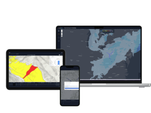
Want to see this in action?
See how Teren transforms geospatial data into critical insights that help businesses and governments build and operate infrastructure for climate resilience.
How can Teren help you?
We'd love to hear from you.
- Ready to dive deeper? -
Knowledge Hub
White Papers
Webinars