In the ever-evolving field of land and forestry management, the ability to analyze and interpret data has become crucial for sustainable decision-making. With the integration of advanced analytics, professionals can now monitor and manage natural resources more effectively, ensuring that forests and openlands are preserved for future generations.
Here, we explore 10 key analytics shaping the future for anyone working in land and forestry management.
1. Vegetation Health and Biomass Monitoring
One of the foundational aspects of forestry management is understanding the health and coverage of vegetation. Analytics tools like the Normalized Difference Vegetation Index (NDVI) allow managers to assess vegetation health by analyzing satellite or aerial imagery. NDVI helps in detecting stressed areas, which can be crucial for timely intervention.
Additionally, biomass estimation is another critical tool that quantifies the amount of organic material in a given area. This data is invaluable for carbon stock assessments and in planning sustainable harvesting practices. Understanding the density and distribution of biomass helps in maintaining ecological balance and supports global carbon sequestration efforts.
2. Soil Analysis for Sustainable Land Management
Healthy soil is the backbone of any thriving ecosystem. Analytics tools that track soil moisture content are essential for managing irrigation, reducing the effects of droughts, and understanding the risk of wildfires. By monitoring moisture levels, forestry managers can ensure that forests and lands are maintained in optimal conditions.
3. Land Use and Land Cover Change Detection
Understanding how land use and cover are changing over time is vital for managing forest resources effectively. Land cover mapping identifies changes such as deforestation, urbanization, or agricultural expansion. These insights are crucial for developing conservation strategies and ensuring sustainable land use.
Deforestation alerts are another critical tool, providing real-time notifications of illegal logging or land clearance. These alerts enable rapid response and enforcement actions, helping to protect valuable forested areas from unsanctioned exploitation.
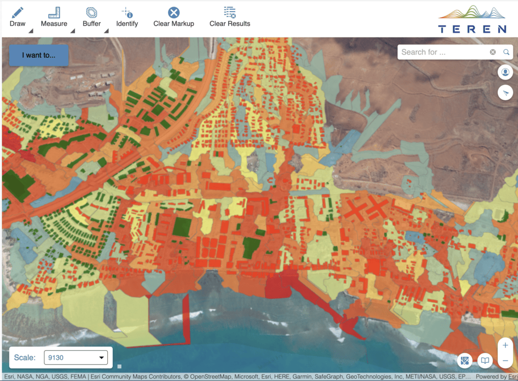
4. Wildfire Risk Assessment and Monitoring
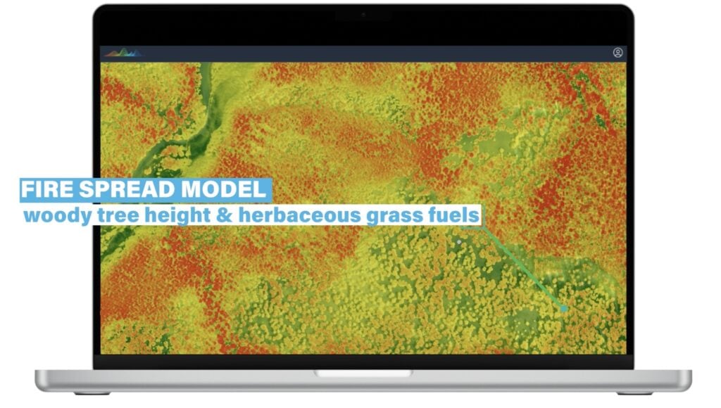
Wildfires pose a significant threat to forests worldwide. Analytics tools like the Fire Weather Index (FWI) help predict the likelihood and intensity of wildfires by analyzing weather conditions, fuel moisture, and topography. This predictive capability is vital for preparing mitigation strategies and protecting forests from devastating fires.
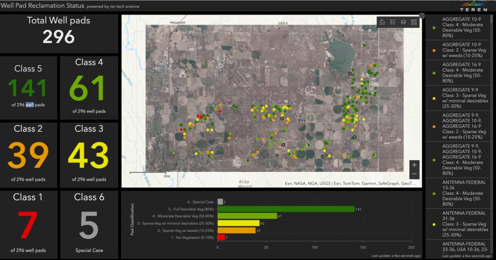
The injection of quantum computing and AI into these analytics is an exciting development in this realm of analytics. For example, Teren is working with the NRCS Conservation Effects Assessment Project on Grazing Lands (CEAP-Grazing Lands) to develop a framework for optimized wildfire risk reduction and recovery via improved fuel hazard analysis and the prioritization of treatment zones for optimized fire and post-fire risk reduction.
5. Biodiversity and Wildlife Habitat Monitoring
Protecting biodiversity is a key component of sustainable forestry management. Habitat suitability models determine the best areas for conserving or restoring habitats for specific species. These models ensure that conservation efforts are targeted and effective, helping to preserve biodiversity in managed lands.
Species distribution modeling predicts where species are likely to be found based on environmental conditions. This information is crucial for planning conservation efforts and managing land use in a way that supports wildlife populations.
6. Water Resources Management
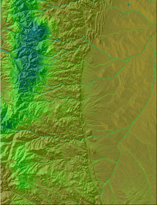
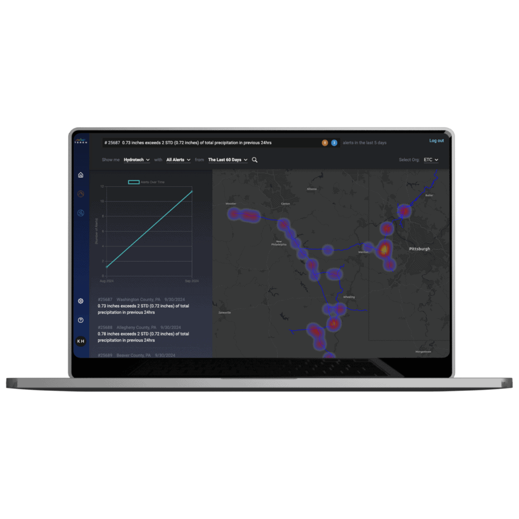
Water is a critical resource in any ecosystem, and its management is a top priority in forestry. Watershed analysis assesses water flow, erosion risks, and potential areas for conservation, helping to maintain healthy water systems. Proper watershed management is essential for sustaining both aquatic and terrestrial ecosystems.
Monitoring aquatic ecosystem health through water quality and aquatic life assessments ensures that rivers, lakes, and wetlands remain vibrant and productive. This data supports conservation efforts and guides sustainable land-use practices that protect water resources.
7. Carbon Sequestration and Emissions Tracking
Forests play a significant role in carbon sequestration, helping to mitigate climate change. Carbon stock analysis measures the amount of carbon stored in forests, supporting carbon offset projects and helping to balance carbon emissions.
Tracking greenhouse gas emissions from land-use changes, such as deforestation or wetland drainage, is also critical. This data helps land managers understand the environmental impact of their activities and develop strategies to minimize emissions.
8. Sustainable Harvesting and Yield Optimization
Sustainable resource use is a cornerstone of forestry management. Forest inventory management tracks tree species, sizes, and densities, providing data for optimizing sustainable harvesting practices. This ensures that forests are harvested responsibly, preserving them for future use.
Growth modeling predicts future forest growth and yield under different management scenarios, helping to plan long-term harvesting strategies. By understanding how forests will develop over time, managers can make informed decisions that balance resource use with conservation.
9. Erosion and Landslide Risk Analysis
Soil erosion and landslides can have devastating effects on forests and surrounding communities. Erosion modeling identifies areas at risk of soil erosion, allowing for the implementation of preventive measures such as reforestation or terracing.
Landslide susceptibility mapping predicts potential landslide zones based on terrain, vegetation cover, and soil stability. This data is crucial for planning safe land use and protecting both natural resources and human settlements.
10. Climate Impact Analysis
Climate change is a significant concern for land and forestry management. Climate change projections model how future climate scenarios might affect forest health, species distribution, and wildfire risk. This information is vital for developing adaptation strategies and ensuring the long-term sustainability of forestry practices.
Conclusion
Incorporating advanced analytics into land and forestry management is essential for making informed, sustainable decisions. From monitoring vegetation health to predicting wildfire risks, these tools provide the insights needed to manage natural resources effectively. By leveraging these analytics, forestry managers can ensure that forests and lands are preserved and managed responsibly, contributing to a healthier planet for future generations.
How can Teren help you?
We'd love to hear from you.
- Ready to dive deeper? -
Knowledge Hub
White Papers
Webinars