Introduction
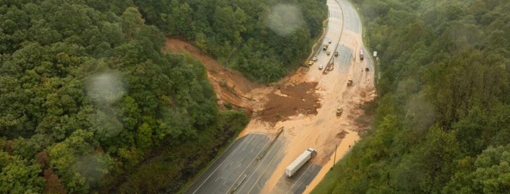
Nature has few forces as swift and destructive as debris flows. These geological phenomena are more than just landslides – they’re powerful, unpredictable forces that can change terrain in an instant. They occur in a wide variety of environments and generally happen during intense rainfall or rapid snowmelt, often starting on hillsides or mountains. Debris flows can travel at speeds up to 35 mph and carry large items like boulders, trees, and cars.
What Are Debris Flows? The Basics Explained

Debris flows are a specific type of landslide (of which there are 10, as outlined by the USGS) characterized by the rapid downslope movement of a water-saturated mixture of soil, rock, and other debris. They are distinct from other types of landslides:
- Rotational landslides involve the rotational sliding of a coherent block of material along a curved slip surface.
- Translational landslides move along a planar surface with little rotation or backward tilting.
- Rockfalls involve the detachment and rapid downslope movement of individual rocks or boulders.
The key features that define debris flows are:
- Composition: Water, soil, rock, and other material that can carry large objects like boulders, trees, and cars.
- Trigger: Typically initiated by heavy rainfall or rapid snowmelt that saturates the ground and reduces soil cohesion.
- Speed: Can reach extremely high velocities, often exceeding 35 mph, making them highly destructive.
- Terrain: Tend to originate on steep slopes or mountainsides and flow rapidly downhill.
The combination of speed, destructive power, and unpredictable nature makes debris flows particularly dangerous geological events that can devastate areas in their path without warning.
Causes and Triggers of Debris Flows

Debris flows can be triggered by a variety of geological and meteorological factors:
- Geological factors: Factors like slope stability and soil types affect whether a slope is more or less prone to failure.
- Meteorological triggers: Weather is a major trigger of debris flows. Events like heavy, prolonged rainfall that saturates soil, or rapid snowmelt (or a combination of the two) are quick to get debris flowing.
- Human-induced causes: Land development that often occurs for infrastructure projects alters natural drainage patterns. Deforestation performed to clear right-of-way areas reduces slope stabilization from vegetation.
With these factors in mind, it goes without saying that certain regions are more susceptible to debris flows than others. Mountainous areas, recently burned landscapes, and regions with intense seasonal rainfall are particularly prone. Climate change is also increasing the frequency and severity of debris flow events in some regions by intensifying weather patterns that trigger these flows.
The Destructive Impact of Debris Flows

- Economic Damages: The U.S. Geological Survey estimated annual losses to be between $2 billion and $4 billion per year. Debris flows often result in significant financial losses for communities, industries, and governments. They can destroy residential and commercial properties, disrupt transportation networks, and damage critical infrastructure such as pipelines, power lines, and communication systems. Cleanup and reconstruction costs can quickly escalate, with insurance claims and government disaster aid adding further financial strain.
- Environmental Consequences: Beyond the immediate physical destruction, debris flows cause profound ecological disruption. They can strip vegetation, erode topsoil, and deposit large volumes of sediment and debris in river systems, altering natural water flow and degrading aquatic habitats.
- Threats to Human Life: As demonstrated by recent Hurricanes like Helene and its resulting 2,000+ landslides, debris flows are a direct threat to communities, especially those located near mountains, valleys, or wildfire-scarred regions. Entire neighborhoods have been buried under mud and rock, with tragic loss of life.
- Infrastructure Vulnerabilities: Critical infrastructure is often ill-prepared to withstand the force of a debris flow. Roads, bridges, railways, and pipelines are particularly vulnerable, as the sheer weight and velocity of debris can cause structural collapse. Infrastructure damage from debris flows can take months to repair, leaving communities and industries stranded in the interim.
Prediction and Monitoring Technologies

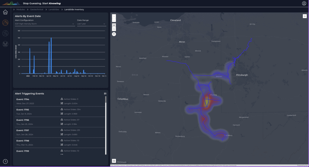
- Modern Detection Systems: Advancements in detection systems enable precise tracking of conditions that lead to debris flows. Ground-based sensors monitor soil moisture, rainfall intensity, and slope movement in real time, providing critical data to predict potential events and reduce response times.
- Geological and Meteorological Monitoring Techniques: Geological monitoring involves tracking changes in land stability, such as cracks or shifts in terrain, while meteorological techniques analyze weather patterns, particularly heavy rainfall or rapid snowmelt. Technology that combines these approaches, like Terevue, allow experts to model and predict high-risk scenarios more accurately.
- Satellite and Remote Sensing Technologies: Satellite imagery and LiDAR provide a comprehensive view of at-risk landscapes, identifying changes in vegetation, soil erosion, and topography.
- Early Warning Systems: Automated systems integrate data from sensors, weather forecasts, and geospatial analyses to issue timely alerts. These warnings help communities and industries take preventative actions, such as evacuations or infrastructure reinforcement, before a debris flow occurs.
- Role of Artificial Intelligence in Prediction: AI and machine learning analyze vast datasets, uncovering patterns that humans might miss. These technologies improve predictive models by factoring in variables like historical data, real-time sensor input, and climate trends, enhancing accuracy and speed in forecasting debris flows.
Mitigation and Prevention Strategies
Once you’ve used the above prediction and monitoring strategies to identify at-risk landscapes, here are some measures professionals take to mitigate and prevent debris flows:

- Engineering Solutions: Interventions like debris barriers, diversion channels, and deflection structures are designed to control and redirect debris flows, minimizing damage. These structures are strategically placed to protect critical infrastructure and human settlements, often tailored to the unique topography of an area.
- Land Use Planning and Zoning: Proactive land use policies and zoning regulations prevent development in high-risk areas, such as steep slopes or floodplains prone to debris flows. By incorporating geospatial data and hazard maps, planners can prioritize safer construction practices and designate buffer zones to reduce exposure.
- Risk Assessment Methodologies: Comprehensive risk assessments identify vulnerable areas and assets, guiding decision-makers in prioritizing mitigation efforts. Advanced tools, including geospatial analytics and predictive modeling, help quantify risks and inform targeted interventions.
- Emergency Response Planning: Robust response plans outline coordinated actions during and after debris flow events. This includes pre-positioning resources, defining evacuation routes, establishing communication protocols, and education and awareness programs.
Conclusion
Debris flows represent a complex and dynamic natural hazard that demands our continued attention and proactive management. By understanding their mechanisms, investing in advanced monitoring technologies, and implementing robust mitigation strategies, we can better protect our communities and landscapes from these devastating geological events.
Learn about Teren’s debris flow modeling.


How can Teren help you?
We'd love to hear from you.
- Ready to dive deeper? -
Knowledge Hub
White Papers
Webinars